Hey, remember when we all lived in New Albion, just south of New Georgia?
January 10, 2011
Mr. Pencil and I finally got around to framing some things—Pencilhaven has an epic backlog of framing—and I’d like to share it with you. Mr. P went through a self-professed eBay-cartography binge a few months ago, and, as a result, we have some nifty new specimens. There should also be a (what I think to be) even better example in the coming week or so.
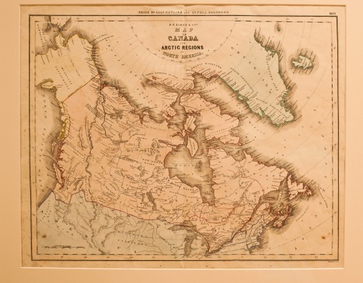
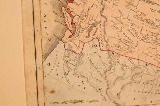
This map is a gold mine of pre-Victorian miscellany and invention, construed by a heavily British cartographer. A bold southward sweep of the southwestern edge of Canada puts what is currently Washington state (excuse me, New Georgia) squarely under the Canadian thumb. This was well before Britain conceded Oregon territory to us Yanks, and indeed the map was produced during the run-up of tensions around the Oregon boundary dispute (“fifty-four forty or fight!”, which we didn’t). So repellent was the notion of Oregon, apparently, that on this map the name is eschewed entirely in favor of the wildly original combination of “New Calafornia [sic]” and “New Albion.” Regarding the latter, I guess “New England” was already taken.
According to seller notes, this map was “COMPILED UNDER THE SUPERINTENDENCE OF THE SOCIETY FOR THE DIFFUSION OF USEFUL KNOWLEDGE, ET CETERA,” which is charming. Charming enough, that, according to Wikipedia:
References to the Society are rare in the modern era, but within Steampunk culture, it is not entirely uncommon to refer to the Society itself and/or its better-known publications in an attempt to lend Victorian verisimilitude.
Of course.
The Quarellers of the MacKenzie
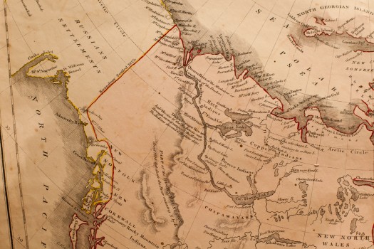
The depiction of the northern lands is long on flair. A 19th-century traveler, heading north, would pass through New Cornwall and New Norfolk (we rather lamely call these places British Columbia these days), and, heading east over PART OF THE ROCKY MOUNTAINS might cross the Daha Dinnee River, “half the size of the Mackenzie, cuts through several ranges of the Mounts; The Indians descend it in three days.” Continuing beyond the Arctic Circle, one descends toward the Arctic Ocean, past “The Quarrellers of the MacKenzie, or, Leucheux of the Traders.” I would love to meet those quarrellers. If one went west instead, one might arrive at the RUSSIANS SETTLEMENTS, i.e., Alaska.
Recently Reviewed
Get the Books
Read my Reviews
Related Posts
- PDX History: Chew on This–Our Foreign Origins
May 19, 2008 - Local History Quickie: Oregon City's Municipal Elevator
May 20, 2008 - Albanian Custom Fades – Woman as Family Man – NYTimes.com
June 26, 2008 - A Piece of (Local) History
March 21, 2009 - Knowledge: The year the trees stopped counting
January 20, 2010

